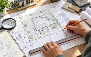
A site plan scale shows how distances on a drawing relate to actual measurements on your property. For example, a scale of 1″=10′ means one inch on the drawing represents 10 feet on the ground, while 1″=20′ means one inch represents 20 feet. Choosing the right scale helps make your property layout accurate, readable, and suitable for permit review.
At Permit For Site Plan, we help homeowners, contractors, and property owners prepare site plans for building permit applications. We understand that choosing between different drawing scales can be confusing, especially when local building departments have specific requirements. This guide explains common scales, when to use them, and how to avoid measurement and printing mistakes.
What Does Site Plan Scale Mean?
A site plan scale is the proportional relationship between a drawing and the actual property. Since a full-size property cannot fit on paper, we reduce its dimensions while maintaining the correct proportions between buildings, boundaries, driveways, and other features.
For example, at 1″=20′, a driveway measuring 40 feet long appears two inches long on the drawing. We use consistent measurements throughout our site plan for permit services to create drawings that clearly represent property layouts.
A properly scaled drawing helps permit reviewers understand where proposed construction will sit in relation to property lines, existing structures, and required setbacks.
Common Scales Used on Residential Site Plans
Residential drawings commonly use engineering scales expressed in inches and feet. The appropriate choice depends on property size, drawing complexity, and the submission requirements of the local jurisdiction.
| Drawing scale | Actual distance per inch | Common application |
|---|---|---|
| 1″=10′ | 10 feet | Small lots and detailed layouts |
| 1″=20′ | 20 feet | Standard residential properties |
| 1″=30′ | 30 feet | Medium-sized properties |
| 1″=40′ | 40 feet | Larger residential lots |
| 1″=50′ | 50 feet | Large parcels and small commercial sites |
| 1″=100′ | 100 feet | Large developments and overview drawings |
These scales are examples rather than universal standards. We recommend checking your local permit instructions before selecting a scale. You can also review our site plan example for permit to understand how property features appear on a completed drawing.
When Is a 1″=10′ Site Plan Scale Useful?
A 1″=10′ scale provides more drawing space for individual property features. Because one inch represents only 10 feet, smaller structures, narrow setbacks, and detailed measurements appear larger on paper.
We generally consider this scale for compact residential lots, detailed additions, or projects where several features occupy a limited area. It can be particularly helpful when preparing a deck permit site plan that needs to show precise distances between the proposed deck, house, and property boundaries.
However, larger properties may not fit comfortably on a standard sheet at this scale. In those situations, we evaluate a smaller drawing scale or a larger sheet size.
When Is a 1″=20′ Site Plan Scale Useful?
A 1″=20′ scale is a common choice for residential site plans because it balances drawing detail with overall property coverage. At this scale, a 100-foot property dimension occupies five inches on paper.
We often consider it when preparing residential site plans involving house additions, garages, driveways, or other improvements. It can provide sufficient room for property boundaries, building footprints, setbacks, and essential dimensions without overcrowding the drawing.
Although widely used, 1″=20′ is not automatically acceptable everywhere. We always recommend confirming the jurisdiction’s scale and sheet-size requirements before finalizing a permit drawing.
Larger Lots and Alternative Site Plan Scales
Larger properties may require scales such as 1″=30′, 1″=40′, 1″=50′, or 1″=100′. These scales allow more land to appear on one sheet, but smaller details become harder to read.
For example, a 200-foot property dimension occupies 10 inches at 1″=20′, but only four inches at 1″=50′. We select a scale that provides adequate property coverage without sacrificing essential information.
For complex projects, our professional drafting services can help organize dimensions, labels, and drawing details. Some projects may also benefit from separate enlarged detail drawings rather than forcing every measurement onto one crowded sheet.
How Scale Affects Site Plan Readability and Dimensions
A drawing can be mathematically accurate yet difficult to review if its labels, dimensions, or property features are too small. Good scale selection should make the entire plan understandable.
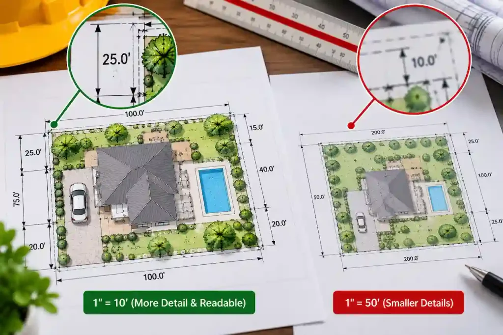
We pay particular attention to three elements:
- Property dimensions: Boundary lengths and setbacks must remain clearly identifiable.
- Building footprints: Existing and proposed structures should be distinguishable.
- Annotations: Measurements, labels, and symbols must remain readable at the intended sheet size.
For projects involving setback restrictions, we also recommend understanding how to measure permit setback requirements. Drawing scale supports accurate presentation, but it cannot correct inaccurate source measurements.
Common PDF Printing Mistakes That Change Drawing Scale
Printing is one of the most overlooked problems in permit drawing preparation. A correctly scaled digital drawing can become inaccurate when a PDF viewer automatically resizes it.
Common mistakes include:
- Selecting “Fit to Page” instead of printing at actual size.
- Printing a large-format drawing on smaller paper without accounting for the reduction.
- Measuring distances directly from a resized PDF using the original written scale.
For example, a drawing prepared at 1″=20′ will no longer measure correctly with a physical ruler if the entire sheet is reduced during printing.
We recommend reviewing the intended sheet dimensions and printing instructions before submitting a building permit site plan.
How to Check Site Plan Scale After Printing
Checking a printed drawing is straightforward when you have a known dimension or a graphic scale bar. We recommend completing this verification before relying on physical ruler measurements.
- Confirm that the printed sheet matches the intended paper size.
- Locate a clearly labeled property dimension or graphic scale bar.
- Measure the corresponding line with an appropriate engineering scale ruler.
- Compare the measured distance with the stated drawing dimension.
- If the measurements disagree, check the PDF printing settings before proceeding.
For example, a 40-foot line should measure two inches at 1″=20′. If it measures less, the printed drawing may have been reduced.
Our site plan scale calculator can also help you understand the relationship between drawing measurements and actual distances.
What If Your Jurisdiction Requires a Specific Scale?
Local building departments may specify acceptable scales, sheet sizes, dimensioning conventions, or drawing formats. These instructions take priority over general recommendations.
Before preparing your submission, we suggest reviewing the jurisdiction’s published checklist and confirming whether different drawing types require different scales. A residential addition may have different presentation requirements from a large commercial development.
If you already have a permit checklist, we can help you identify the appropriate drawing requirements and prepare the necessary documentation. Our site plan requirements guide also explains other information commonly needed for permit review.
Get a Site Plan Prepared at the Required Scale
Choosing the correct drawing scale helps make permit plans clearer, easier to review, and more useful for construction planning. Whether your project involves a small residential addition or a larger property improvement, we can help organize the drawing around the required dimensions and submission format.
If your permit office specifies a drawing scale, send us the checklist along with your project details. Through our custom quote request page, we can review your requirements and help you move forward with professional site plan preparation.
Frequently Asked Questions About Site Plan Scales
1. What is the most common site plan scale?
The 1″=20′ scale is commonly used for residential site plans because it balances detail and property coverage. However, local requirements and project dimensions determine whether it is appropriate.
2. Is 1″=10′ larger than 1″=20′?
Yes. At 1″=10′, property features appear twice as large as they do at 1″=20′, assuming the same actual dimensions.
3. Can I use different scales on one site plan?
Yes, separate drawing views or detail areas may use different scales when clearly labeled. The main site plan should remain consistent within its own drawing view.
4. Does every permit office require a scale bar?
Not necessarily. Requirements vary by jurisdiction, although a graphic scale bar is useful because it changes proportionally when a drawing is resized.
5. Can I submit a site plan without a scale?
Some jurisdictions may accept simplified sketches for limited projects, but many permit applications require scaled drawings. Always verify the applicable submission instructions.
6. How do I choose the correct scale for my property?
Start with the property’s dimensions, intended paper size, and required drawing details. Then confirm the scale against the local permit checklist.
7. Does changing the drawing scale change actual property dimensions?
No. Changing the scale only changes how large property features appear on paper. Actual property measurements remain unchanged.