
The best way to understand what a site plan example for permit should look like is to examine the elements that city reviewers expect to see on a permit-ready drawing. While requirements vary by jurisdiction, most building departments require accurate property boundaries, setback dimensions, existing structures, proposed improvements, and properly formatted title block information.
This guide explains what a permit-ready site plan looks like, provides practical site plan examples for common permit types, and includes a complete checklist to help property owners avoid permit review delays and drawing rejections.
Whether you are applying for a fence permit, pool permit, ADU permit, or other residential project, reviewing a professional site plan example can help you prepare a stronger permit submission.
Visual Site Plan Example for Permit
Educational example notice: This article discusses common drawing elements and illustrative permit scenarios. It does not document a specific municipal approval.
A permit-ready site plan typically includes clearly labeled property boundaries, existing structures, proposed improvements, setback dimensions, a north arrow, scale information, and a complete title block. When reviewing a site plan example for permit approval, city reviewers should be able to quickly identify:
- Property lines and dimensions
- Existing buildings and structures
- Proposed construction
- Setback measurements
- Utility locations
- Driveways and access points
- North arrow and drawing scale
- Property identification information
A complete and accurate drawing helps reviewers verify compliance and process permit applications more efficiently.If you’re unfamiliar with site plan symbols, dimensions, and labels, learning how to read a site plan can help you understand what reviewers look for during permit review.
Get a Professional Site Plan Example — Built for Your Permit — $99
Professional, permit-ready site plans starting at $99. Standard Basic and Standard scopes typically target 24–48 hours. Nationwide online drafting support.
✅ permit-focused drafting and revision support | ✅ reviewer-requested revisions within the original agreed scope | ✅ the published cancellation and refund policy
What Makes a Site Plan “Permit-Ready”?
A permit-ready site plan is more than a simple sketch of a property. It is a technical drawing used by building departments to verify zoning compliance, property information, and construction requirements before permit approval. A professional Site Plan Example should:
- Be drawn to the scale required by the local jurisdiction
- Include all items required by the permit submission checklist
- Contain a complete and properly formatted title block
- Accurately reflect existing site conditions
- Show all setback dimensions with exact measurements
- Clearly identify proposed improvements
- Include property boundaries and structure locations
Incomplete or inaccurate site plans are among the most common causes of permit review delays and correction requests.
Elements Found in Every Permit Site Plan
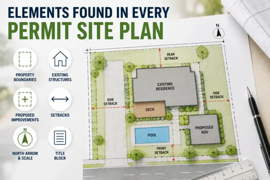
Although permit requirements vary by city, most permit-ready site plans include several essential elements that help building departments review your application efficiently.
| Element | Purpose |
|---|---|
| Property Boundaries | Define the legal limits of the property and help verify zoning compliance. |
| Existing Structures | Show all existing buildings, garages, sheds, pools, and other improvements on the property. |
| Proposed Improvements | Identify all new structures, additions, or modifications with accurate dimensions. |
| Setbacks | Display the required distances between structures and property lines to ensure code compliance. |
| North Arrow & Scale | Help reviewers understand the drawing’s orientation and accurately measure distances. |
| Title Block | Includes the property address, parcel number, legal description, preparer information, drawing scale, and drawing date. |
Site Plan Example For Permit: Fence Permit
Property Example
80′ × 120′ residential lot with a proposed 6-foot privacy fence along the rear and side property lines.
What the Drawing Shows
- Property boundary rectangle with all sides dimensioned
- Existing residence footprint clearly labeled
- Existing driveway identified
- Proposed fence location shown using a dashed line
- Fence labeled “PROPOSED 6′ PRIVACY FENCE”
- Setback distances shown where required
- North arrow included
- Graphic scale displayed
- Complete title block with property information
Why Reviewers Need This Information
City reviewers use fence permit site plans to verify property boundaries, fence placement, easements, and compliance with local setback regulations. A properly prepared site plan for fence permit applications can help prevent review delays and correction requests. Accurate dimensions reduce review delays and help prevent permit rejection.
Site Plan Example: Pool Permit
Property Example
75′ × 110′ residential lot with a proposed 15′ × 30′ inground swimming pool.
What the Drawing Shows
- Property boundaries and dimensions
- Existing house and patio
- Proposed pool location and dimensions
- Rear and side setback measurements
- Distance between pool and residence
- Pool enclosure or safety barrier
- Equipment pad location
- Gate locations and access points
Why Pool Site Plans Receive Extra Review
Swimming pool permits often require additional safety review. Building departments typically evaluate barrier requirements, gate placement, equipment locations, utility clearances, and setback compliance before approval. For pool permits, see our site plan services and pricing page.
Site Plan Example: ADU Permit
Property: 60′ × 100′ lot in Phoenix, AZ. Proposed: 400 sq ft detached ADU in rear yard.
What the drawing shows:
- Both primary residence and proposed ADU footprints shown
- ADU labeled “PROPOSED ADU — 20′ × 20′”
- Setbacks from ADU to all property lines
- Setback from ADU to primary house
- Utility connections noted (gas, electric, sewer)
- Parking space shown (required in many jurisdictions for ADUs)
Before submitting plans, property owners should review local ADU permit requirements to verify setback, parking, and utility regulations. For ADU plans, check our services or our FAQs.
Complete Site Plan Checklist
Before submitting your permit application, take a few minutes to review your Site Plan Examples against this checklist. Confirming these essential details before submission can help reduce correction notices, prevent unnecessary delays, and improve your chances of receiving permit approval on the first review.
Universal Checklist (Applies to Most Permit Types)
- Drawn to the correct scale for your jurisdiction
- Graphic (bar) scale included on the drawing
- North arrow clearly shown
- All property lines drawn and dimensioned
- Adjacent street name(s) labeled
- All existing structures shown and labeled
- Proposed improvement clearly marked as “PROPOSED”
- All setback distances labeled with measurements
- Parcel ID (APN) included in the title block
- Property address included in the title block
- Legal description included in the title block
- Preparer’s name and drawing date included in the title block
Completing this checklist before submitting your Site Plan Example can save time during the review process and reduce the likelihood of revision requests from your local building department. Use our Free Permit Submission Checklist Generator for a jurisdiction-specific checklist.
What Separates Approved Plans from Rejected Ones
In illustrative site-plan examples, these are important drawing-quality distinctions. Better-documented examples: exact scale, numbered setback dimensions, complete title block. Potential review issues: “approximately” to scale, visual setbacks without numbers, missing parcel ID or legal description.Many of these site plan errors are preventable when drawings are reviewed for accuracy before submission.
If your plan has been rejected, use our Permit Rejection Fix Tool to identify the fix. Or read our client reviews to see how we’ve helped others get approved.
Get a Permit-Ready Site Plan — Built to Pass. $99 · 24 Hours · All 50 States.
Professional, permit-ready site plans starting at $99. Standard Basic and Standard scopes typically target 24–48 hours. Nationwide online drafting support.
✅ permit-focused drafting and revision support | ✅ reviewer-requested revisions within the original agreed scope | ✅ the published cancellation and refund policy
Frequently Asked Questions
What should a site plan for a permit look like?
A permit site plan should be a clean, to-scale CAD drawing showing property lines with dimensions, all existing structures, the proposed improvement labeled “PROPOSED,” setback distances with numbers, a north arrow, bar scale, and a complete title block with parcel ID and legal description.
Where can I see an example of a site plan for a permit?
Permit For SitePlan provides examples for each permit type. Your local building department’s website may also have sample drawings. The key is that the example must match your jurisdiction’s specific requirements — not just a generic template.
Can I copy a site plan example and edit it for my property?
Not recommended. Even if the format is correct, copying an example means filling in dimensions and data specific to your lot — which still requires gathering parcel records, GIS data, and knowing your jurisdiction’s setback rules. A professional drafting service does all of this for $99.
What does “drawn to scale” mean on a site plan?
It means every distance on the drawing represents a consistent real-world measurement. At 1″=20′ scale, 1 inch on paper = 20 feet of actual property. Buildings, setbacks, and property lines must all follow this ratio exactly.
What is a title block on a site plan example?
The title block is the information box (usually bottom-right) showing the property address, parcel ID, legal description, scale, north arrow, preparer name, and date. Every jurisdiction requires this — and missing elements here cause immediate rejection.
Do site plan examples differ by permit type?
Yes. A fence permit site plan is simpler than a pool permit plan, which is simpler than a commercial site plan. Each permit type has different required elements. We produce the right version for your specific permit and jurisdiction.