A plat map is one of the most useful property documents for homeowners, contractors, and permit applicants. It provides an official record of lot boundaries, easements, streets, and subdivision layouts that local jurisdictions use when reviewing development projects.
Understanding how this recorded property document relates to your site plan can help you avoid boundary conflicts, setback violations, and permit delays. This guide explains what a property map is, what information it contains, and how it affects permit approvals.
What Is a Plat Map?
A plat map is an official recorded document that shows how a larger parcel of land has been divided into individual lots within a subdivision. Prepared by a licensed surveyor and filed with the county recorder, it becomes part of the permanent public record. A typical recorded subdivision map identifies:
- Property boundaries
- Lot dimensions
- Streets and rights-of-way
- Easements
- Block numbers
- Common areas
- Legal descriptions
Because permit reviewers often reference these recorded land records during the review process, a plat map plays an important role in determining whether a proposed project complies with local zoning and development regulations.
Why Plat Maps Matter for Permit Applications
Before approving a permit application, building departments must verify that proposed construction fits within the legal boundaries of the property. A plat map helps reviewers confirm key property details, including:
- Lot dimensions
- Property boundaries
- Easement locations
- Street frontage
- Access requirements
- Subdivision restrictions
Without accurate property records, projects may violate setback requirements or encroach into protected easement areas, resulting in permit delays or required revisions.
What Information Appears on a property map?
Most recorded subdivision maps include the following information:
| Property Information | Boundary Information | Development Information | Survey Information |
|---|---|---|---|
| Lot numbers | Lot dimensions | Streets | North arrow |
| Block numbers | Property lines | Rights-of-way | Scale |
| Legal descriptions | Corner markers | Utility easements | Surveyor certification |
| Parcel references | Drainage easements | Recording information | |
| Common areas |
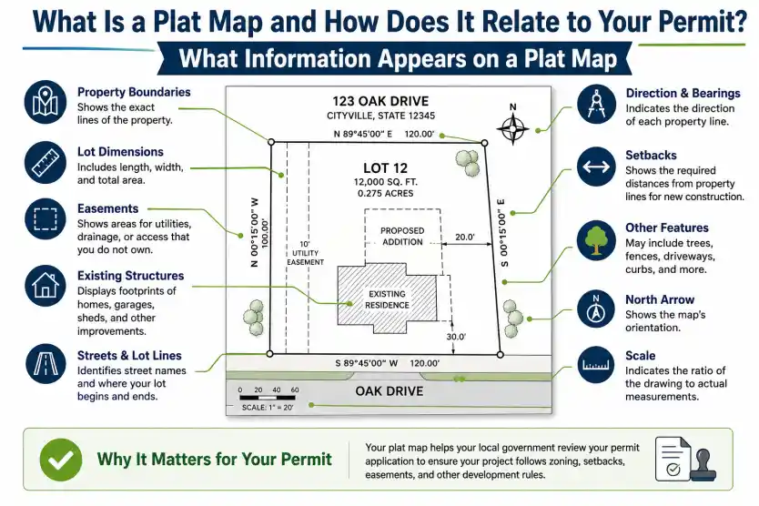
Understanding these elements helps homeowners prepare accurate permit drawings, verify property boundaries, and reduce the risk of delays during the permit review process.
Understanding Easements on a Plat Map
One of the most important features shown on a property map is an easement. An easement grants certain rights over a portion of a property for specific purposes, such as:
- Utility lines
- Drainage systems
- Access roads
- Public infrastructure
Many cities restrict construction within easement areas. Building inside an easement can lead to permit denial, required redesigns, or even the future removal of structures.
How Recorded Plat Maps Relate to Building Permits
When a permit application is submitted, reviewers often compare the proposed site plan with the recorded subdivision plan to verify:
- Correct lot dimensions
- Property boundaries
- Easement locations
- Setback compliance
- Building placement
- Access requirements
If the proposed site plan conflicts with the recorded property layout, the application may require corrections or be rejected.
Plat Maps, Setbacks, and Buildable Area
This recorded subdivision plat helps determine the buildable area of a property by identifying boundaries, easements, and other land features. These details are used to calculate:
- Front setbacks
- Rear setbacks
- Side setbacks
- Lot coverage limitations
Without accurate property records, setback calculations may be incorrect, increasing the risk of permit delays or rejection.
WWhere to Find Your Property’s Plat Map
Most homeowners can obtain a recorded plat through a variety of official public records and local government resources. These documents are typically maintained by county or municipal agencies and can be accessed online or in person. Having the correct recorded plat before preparing permit drawings helps verify property boundaries, easements, lot dimensions, and other important details required during the permit review process.
Online Sources
- County GIS systems
- Assessor websites
- County recorder’s office
- Property information portals
Offline Sources
- County courthouse records
- Licensed surveyors
- Title companies
- Local planning departments
Before relying on any property record for your project, verify that you are using the most recently recorded plat. If you’re unsure whether the document is current, contact your local recorder’s office or planning department to confirm that no updated subdivision records have been filed. Using accurate and up-to-date property information can help prevent permit delays, boundary disputes, and costly revisions during construction.
Plat Map vs. Site Plan
| Feature | Plat Map | Site Plan |
|---|---|---|
| Purpose | Records land subdivision | Supports permit application |
| Created By | Licensed surveyor | Designer, architect, or drafter |
| Filed Publicly | Yes | No |
| Shows Existing Lot Layout | Yes | Yes |
| Shows Proposed Improvements | No | Yes |
| Used for Permit Review | Reference document | Primary permit drawing |
What’s the Difference Between a Plat Map and a Property Survey?
Although a recorded plat and a property survey both provide information about a piece of land, they serve different purposes and are used at different stages of a construction or permit project.
| Plat Map | Property Survey |
|---|---|
| Shows the layout of an entire subdivision | Shows the current measurements of a specific property |
| Includes multiple lots, streets, and easements | Verifies property boundary locations |
| Recorded with the local county or municipality | Identifies encroachments or boundary conflicts |
| Used as a public land record | Prepared for an individual property |
While this recorded subdivision document provides the official layout of a subdivision, a property survey confirms the actual conditions and dimensions of an individual parcel. Survey data is often used to verify that property boundaries match the recorded land records, helping homeowners avoid boundary disputes and ensuring permit applications are based on accurate information.
Practical Permit Review Checklist
Before submitting your permit application, review your drawing as if you were the city plan reviewer. The plan should clearly show existing conditions, proposed improvements, where the work will take place, and how the project fits within the property boundaries. Key details should include accurate dimensions, setback distances, a north arrow, the project address, parcel information, and clear labels for both existing and proposed structures. Providing complete and accurate information helps reviewers understand the project quickly and reduces avoidable correction comments.
Before submitting, confirm that you:
- Verify the project address and owner information.
- Label proposed work separately from existing structures.
- Clearly show all setback distances.
- Use consistent measurements across the site plan, floor plan, and supporting drawings.
- Submit the plans in the format required by your local building department.
How to Prepare Your Project Details
Before ordering permit drawings, gather the following information:
- Property address
- Parcel number
- Recorded plat
- Existing property survey
- Photos of the project area
- HOA requirements (if applicable)
- Previous permit documents
Providing your recorded plat and survey documents upfront can reduce revision requests, improve drawing accuracy, and help streamline the permit review process.
Common Mistakes to Avoid
Homeowners frequently make these property documentation mistakes:
- Using outdated recorded plats
- Ignoring easements
- Confusing subdivision records with property surveys
- Assuming fence lines represent legal property boundaries
- Miscalculating setback distances
- Using incorrect lot dimensions
- Submitting plans that conflict with county records
Avoiding these common mistakes can help reduce permit corrections, prevent project delays, and improve the likelihood of a smooth approval process.
Ready to Get Your Permit-Ready Plans?
Whether you’re building an addition, installing a new structure, or preparing drawings for permit approval, having accurate property information is essential. Our team creates permit-ready site Plan and pricings designs to meet local requirements and minimize review delays.
- 24-hour turnaround
- Starting at $79
- Unlimited revisions
- 100% money-back guarantee
Frequently Asked Questions
Is a plat map the same as a survey?
Related but not identical. A plat map records subdivision boundaries for a neighborhood. A survey measures a specific property’s current boundaries. A survey is often used to verify that a property’s actual boundaries match the recorded plat.
Do I need my plat map to apply for a building permit?
Not usually — your building department can look up your property using the address or parcel number. However, having the plat map handy can be useful when preparing your site plan, especially to verify easement locations.
Can a plat map be wrong?
Yes, occasionally. Errors in recorded plats can create boundary disputes, and corrections require a formal process (a “plat amendment” or re-subdivision). If you suspect your boundaries are different from the plat, consult a licensed surveyor.
What is an “unplatted” property?
An unplatted property is one that hasn’t gone through a formal subdivision process — typically rural properties or lots that predate modern subdivision requirements. Permit requirements for unplatted properties are sometimes slightly different.
Why do building departments use plat maps?
Plat maps help verify property boundaries, easements, and lot dimensions before permits are approved.
Can I use a plat map instead of a survey?
Not always. A plat map shows recorded boundaries, while a survey verifies current field conditions.
Does every property have a plat map?
Most subdivided properties do. Some rural or older properties may be unplatted.
Can easements affect where I build?
Yes. Many jurisdictions prohibit construction within utility and drainage easements.
What information should match between my site plan and plat map?
Property boundaries, lot dimensions, easements, and parcel information should all match.