Property line disputes can arise when fences, garages, driveways, or other structures are built without accurately confirming property boundaries. These conflicts may lead to construction delays, legal issues, and unexpected expenses. A property line disputes site plan helps prevent these problems by clearly showing property boundaries, setback distances, easements, existing structures, and proposed improvements. It provides homeowners, contractors, and local building officials with the information needed to ensure a project complies with zoning and permit requirements.
In this guide, you’ll learn how a property line disputes site plan can help resolve boundary disputes, support permit approval, and protect your property before construction begins.
What Are Property Line Disputes?
Property line disputes occur when neighboring property owners disagree about the exact location of their shared boundary. These conflicts often involve fences, driveways, garages, landscaping, or other structures that may extend onto adjacent property.
Many disputes result from outdated surveys, missing property markers, or incorrect assumptions about property lines. A property line disputes site plan helps clearly identify legal boundaries, reducing misunderstandings and ensuring construction complies with local regulations.
What Is a Property Line Disputes Site Plan?
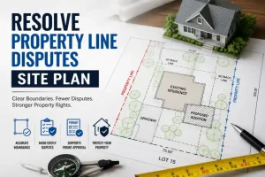
A property line disputes site plan is a detailed drawing that shows a property’s legal boundaries and the location of existing and proposed structures. It is commonly required for building permits, renovations, and property improvements. A typical site plan includes:
- Property boundaries
- Lot dimensions
- Existing and proposed structures
- Setback distances
- Easements
- Driveways
- Utility lines
- Drainage information
By providing a clear layout of the property, a property line disputes site plan helps verify zoning compliance, prevent boundary conflicts, and support permit approval.
Common Causes of Property Line Disputes
Property line disputes often happen when structures or improvements are placed without confirming the exact property boundary. Common causes include:
- Incorrect fence placement that extends onto a neighbor’s property.
- Home additions, garages, or sheds built too close to property lines.
- Driveways and parking areas that cross into neighboring land.
- Landscaping features such as trees, retaining walls, and irrigation systems extending beyond legal boundaries.
- Missing or damaged property markers that make boundary lines difficult to identify.
A professionally prepared property line disputes site plan helps identify legal property boundaries, setback requirements, and access points before construction begins, reducing the risk of costly disputes and corrections.
How a Property Line Disputes Site Plan Helps Resolve Boundary Conflicts
A property line disputes site plan provides an accurate layout of your property, helping homeowners, contractors, and local officials verify property boundaries before construction begins. It reduces misunderstandings, prevents costly mistakes, and supports compliance with local regulations.
Clearly Identifies Property Boundaries
A property line disputes site plan accurately shows your property’s legal boundaries using survey measurements. This helps determine whether fences, driveways, or buildings are within the correct property lines and reduces the risk of boundary disputes.
Confirms Setback Compliance
The site plan displays required setback distances, ensuring new structures meet local zoning regulations. Verifying setbacks before construction helps avoid permit delays, fines, and expensive modifications.
Prevents Construction Encroachments
A property line disputes site plan helps identify potential encroachments before construction begins, preventing structures such as fences, garages, decks, retaining walls, or driveways from extending onto neighboring property.
Supports Permit Approval
Many municipalities require a site plan as part of the permit application process. A complete property line disputes site plan demonstrates compliance with zoning rules, property boundaries, and setback requirements, helping speed up permit approval.
Provides Evidence During Disputes
If a boundary disagreement occurs, a professionally prepared property line disputes site plan serves as valuable supporting documentation. It clearly illustrates property boundaries and can help homeowners, surveyors, and local officials resolve disputes more efficiently.
Key Elements Included in a Property Line Disputes Site Plan
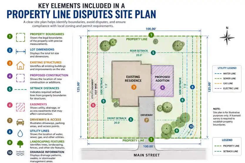
A complete property line disputes site plan contains several important features that help define property ownership and support permit applications.
Property Lines
The plan clearly identifies the legal boundaries of the property using accurate measurements based on survey information. This is the foundation of every site plan and the primary reason it is so valuable during boundary disputes.
Lot Dimensions
The overall size and shape of the property should be clearly labeled. Lot dimensions help verify available building space and ensure proposed improvements remain within legal property limits.
Existing Structures
All existing improvements should appear on the site plan, including:
- House
- Garage
- Shed
- Deck
- Swimming pool
- Fence
- Retaining walls
Showing existing structures allows reviewers to evaluate how future construction will affect the property.
Proposed Improvements
If you’re planning new construction, the site plan should show the exact location of proposed improvements. These may include:
- Home additions
- Detached garages
- Carports
- Decks
- Driveways
- Accessory dwelling units (ADUs)
Displaying these improvements helps confirm that they comply with property boundaries and setback requirements.
Easements
Easements grant utility companies or local governments the right to access specific portions of a property. A property line disputes site plan should clearly identify any:
- Utility easements
- Drainage easements
- Access easements
- Road easements
Building within an easement can lead to permit issues and future legal complications.
Driveways and Access Points
The plan should illustrate how vehicles enter and exit the property. This includes:
- Existing driveway
- Proposed driveway
- Parking areas
- Access roads
Proper access planning also helps ensure compliance with local transportation and safety regulations.
Utility Connections
Most site plans also indicate the location of utility services such as:
- Water lines
- Sewer connections
- Electrical service
- Gas lines
- Stormwater drainage
Including utilities provides a more complete picture of the property and supports permit review.
When Should You Get a Property Line Disputes Site Plan?
Obtaining a property line disputes site plan before starting construction can save both time and money. You should consider having one prepared if you are:
- Building a new home
- Constructing a garage or shed
- Installing a fence
- Building a deck or patio
- Expanding your house
- Replacing a driveway
- Selling your property
- Resolving a boundary disagreement
- Applying for a building permit
Preparing a site plan early allows you to identify potential issues before construction begins, reducing delays and unexpected expenses.
Benefits of Hiring a Professional
Although some homeowners attempt to create their own site plans, hiring an experienced professional offers several important advantages. A qualified designer or drafting service can:
- Produce accurate, permit-ready drawings
- Identify zoning and setback issues early
- Reduce permit revisions
- Improve approval times
- Ensure compliance with local regulations
- Help prevent costly property line disputes
Professional site plans are especially valuable for projects located near property boundaries or involving significant construction.
Common Mistakes to Avoid
Many property owners unintentionally create boundary issues because they skip important planning steps before construction begins. Preparing an accurate property line disputes site plan can help you avoid these common mistakes and reduce the risk of permit delays or legal disputes.
Relying on Old Property Records
Property lines may have changed over time, or older documents may no longer reflect current conditions. Using outdated surveys or inaccurate records can result in construction that crosses legal boundaries.
Ignoring Setback Requirements
Every municipality has setback regulations that determine how close a structure can be built to a property line. Failing to account for these requirements may lead to permit denial or costly modifications.
Not Hiring a Surveyor When Needed
For projects near property boundaries, guessing lot lines is risky. A licensed surveyor can verify boundary locations and provide accurate measurements for your property line disputes site plan.
Failing to Show Easements
Many properties contain utility or drainage easements where construction is restricted. Omitting these areas from your site plan can delay permit approval and create future conflicts.
Starting Construction Without a Site Plan
Beginning construction before preparing a property line disputes site plan increases the likelihood of boundary disputes, code violations, and unexpected project delays.
How Much Does a Property Line Disputes Site Plan Cost?
The cost of preparing a property line disputes site plan depends on factors such as property size, project complexity, and whether a new land survey is required. Here are typical price ranges:
| Service | Estimated Cost |
|---|---|
| Basic residential site plan | $150–$500 |
| Professionally prepared site plan | $300–$1,200 |
| Site plan with property survey | $800–$2,500+ |
Additional costs may apply if your project requires:
- Boundary surveys
- Engineering services
- Zoning reviews
- Permit revisions
- Topographic surveys
While professional site plans involve an upfront investment, they often save money by preventing construction errors, permit issues, and legal disputes.
How to Prepare Your Project Details
A better starting package usually creates a better final drawing. Gather your property address, a short description of the work, photos of the project area, rough measurements, and any instructions from the permit office. If you already have an old survey, plot plan, contractor sketch, or HOA document, include it during the order process. Even when those files are not perfect, they give the drafting team useful context and help prevent missing information.
For homeowners, the goal is not to create a complicated architectural package. The goal is to give the building department a clear, scaled, and easy-to-review drawing. That is why Property Line Disputes: How Site Plans Can Help Resolve Them should focus on accuracy, simple labels, and the specific details your jurisdiction asks for. A clean plan is often easier for the reviewer to approve than a crowded drawing with unnecessary notes.
Conclusion
A property line disputes site plan is an essential tool for preventing and resolving boundary conflicts. It clearly identifies property lines, setbacks, easements, and proposed improvements, helping ensure your project complies with local regulations. Whether you’re installing a fence, building an addition, or applying for a permit, an accurate property line disputes site plan can reduce disputes, avoid costly mistakes, and keep your construction project on track.
Ready to Get Your Permit-Ready Plans?
24-hour turnaround · Starting at $79 · Unlimited revisions · 100% money-back guarantee
Frequently Asked Questions
My neighbor’s fence is on my property. What should I do?
Start by getting a survey to confirm the boundary. If the fence is confirmed to be on your property, send a written notice to the neighbor with the survey results. Most disputes are resolved with evidence. If not, a real estate attorney can advise on the next steps.
Can I use a site plan in court?
A site plan is not a legal boundary document. In court, a licensed survey is the appropriate evidence for property line disputes.
What is adverse possession?
Adverse possession is a legal doctrine where a person who has openly, continuously, and exclusively used a portion of someone else’s property for a certain number of years (varies by state, typically 5–20 years) may claim ownership of that portion.
How do I get my property lines staked?
A licensed land surveyor can physically place stakes or monuments on your property corners and boundary lines. This service is sometimes called “boundary staking” and costs $500–$2,000+, depending on property size and terrain.