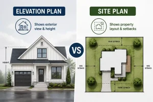

A topographic survey permit site plan is often required when standard property layouts fail to capture terrain shifts. Most residential permits require only a standard site plan. But some projects — particularly those involving significant grading, drainage design, or construction on sloped land — require topographic data as part of the site plan. Understanding when topo is needed can prevent delays. Understanding when this specific topographic survey permit site plan layout is needed can prevent costly project delays.
When preparing construction or development plans, many homeowners assume a standard site plan is enough for every project. While this is true for many residential permits, projects involving steep slopes, drainage improvements, retaining walls, or significant grading often require a topographic survey permit site plan. These specialized drawings provide elevation data that helps engineers, architects, and building departments understand how the land rises and falls before approving construction.
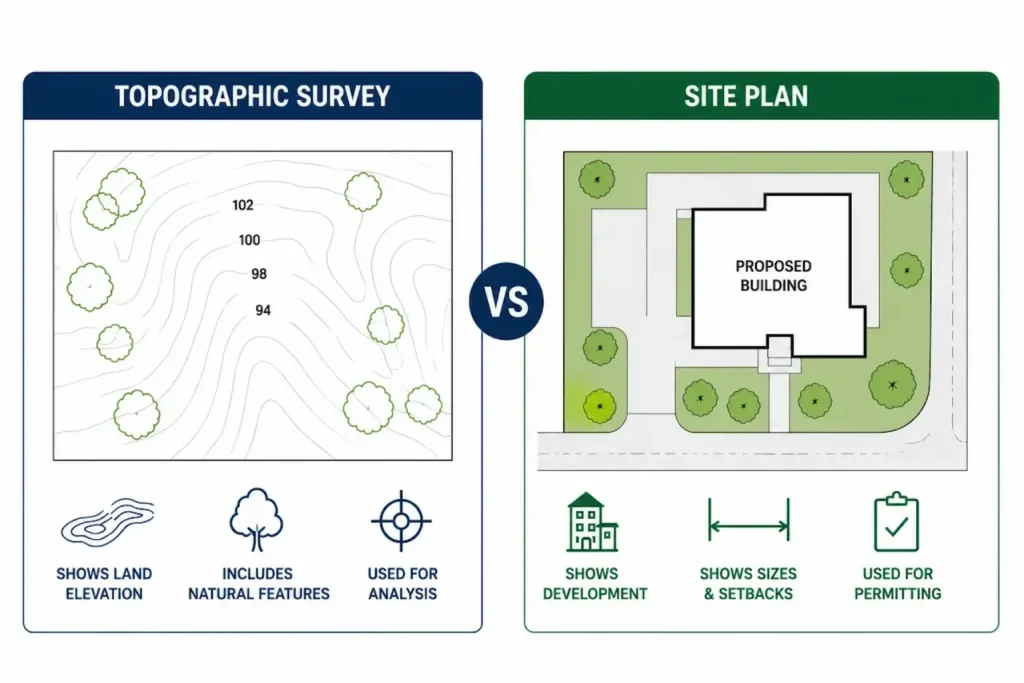
Unlike a traditional site plan that focuses on property boundaries, structures, setbacks, and utilities, a topographic survey permit site plan includes contour lines, spot elevations, and terrain information. This additional data allows reviewers to evaluate drainage patterns, grading impacts, erosion control, and compliance with local development regulations.
- What Is a Topographic Survey?
- What Is a Topographic Site Plan?
- Topographic Survey vs. Standard Site Plan
- Standard Site Plan
- Topographic Survey Permit Site Plan
- When Is a Topographic Site Plan Required?
- Getting Topographic Data
- How We Handle Topo Requirements
- Practical Permit Review Checklist
- How to Prepare Your Project Details
- Common Mistakes to Avoid
- Conclusion
- Why Choose Our Team?
- Frequently Asked Questions
What Is a Topographic Survey Permit?
A topographic survey (topo) measures the elevation of the ground surface at regular intervals across a property and represents these elevations as contour lines on a drawing. Contour lines connect points of equal elevation, creating a visual representation of the terrain’s shape. When merged with a building layout, it becomes a functional topographic survey permit site plan.
These surveys provide far more information than a simple boundary survey. Instead of only locating property corners, they map the landscape itself, allowing engineers and designers to understand the site’s physical characteristics before construction begins. A professional topographic survey permit site plan commonly includes:
- Property boundaries & Existing structures.
- Ground elevations & Contour lines.
- Trees and vegetation.
- Driveways and sidewalks.
- Utility poles & Water features.
- Storm drains.
- Retaining walls.
- Existing grading and Easements.
- Significant natural features.
This information forms the foundation for grading plans, drainage studies, retaining wall designs, subdivision planning, and many complex construction projects.
What Is a Topographic Site Plan?
A topographic survey permit site plan combines a traditional site plan with elevation information collected during a topographic survey. Instead of showing only horizontal property features, it also illustrates the vertical changes in land elevation.
These drawings help reviewers understand how proposed construction interacts with the surrounding terrain and whether the project complies with grading, drainage, and stormwater management requirements.
A complete topographic site plan typically shows:
- Property lines.
- Existing buildings.
- Proposed structures.
- Driveways.
- Setbacks.
- Utility locations.
- Contour lines.
- Spot elevations.
- Drainage flow.
- Easements.
- North arrow.
- Drawing scale.
Because they combine layout and elevation information, these drawings are frequently required for projects involving earthwork or challenging site conditions.
Topographic Survey Permit vs. Standard Site Plan Permit
Although both drawings are used during the permitting process, they serve different purposes. Understanding the difference helps property owners determine which documents their project requires.
Standard Site Plan
A traditional site plan primarily shows the horizontal layout of the property, including:
- Property boundaries.
- Existing structures.
- Proposed construction.
- Setback distances.
- Driveways.
- Walkways.
- Utility locations.
- Lot dimensions.
Standard site plans are commonly sufficient for:
- Fences.
- Detached sheds.
- Decks.
- Swimming pools.
- Small additions.
- Residential remodeling.
Topographic Survey Permit Site Plan
A topographic survey permit site plan provides everything found on a standard site plan while adding elevation data that illustrates existing ground conditions.
Additional information includes:
- Contour lines.
- Spot elevations.
- Slopes.
- Existing grades.
- Drainage paths.
- Retaining walls.
- Earthwork areas.
- Cut-and-fill calculations (when required).
These plans provide engineers and permit reviewers with the information necessary to evaluate grading impacts before approving construction.
When Is a Topographic Survey Permit Plan Required?
Not every project requires topographic information. However, many local building departments request a topographic survey permit site plan whenever changes to land elevation could affect drainage, neighboring properties, or public infrastructure.
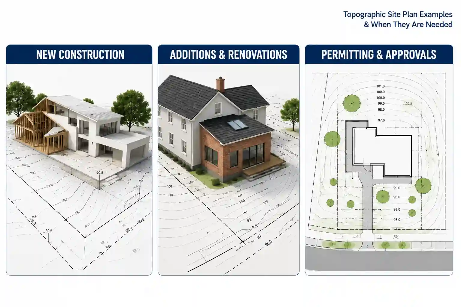
Projects commonly requiring topographic surveys include:
- New construction on sloped land (typically >5% slope)
- Projects requiring significant cut and fill
- Retaining wall permits (especially for taller walls)
- Projects in or near floodplains
- Drainage design and stormwater management plans
- Projects near sensitive natural features (streams, wetlands)
- Some commercial and subdivision applications
- Hillside developments and Grading permits.
- Commercial developments & Road construction.
- Utility infrastructure projects.
Some municipalities also require topographic information whenever construction exceeds certain grading thresholds or alters natural drainage patterns. Checking local permit requirements before beginning design work can prevent costly revisions later.
Getting Topographic Data
Accurate elevation information is essential for preparing a reliable topographic survey permit site plan. The quality of your topographic data directly affects grading calculations, drainage design, engineering accuracy, and permit approval. Choosing the right data source depends on your project’s complexity, budget, and local building department requirements.
High-quality elevation data for your topographic survey permit site plan can come from:
- Licensed land surveyor (most accurate for significant slopes)
- LIDAR data from county GIS (suitable for many permit applications)
- USGS topographic maps (less detailed, for preliminary design only)
- Photogrammetric surveys for large areas
- County GIS databases
- Municipal planning departments
For projects involving significant grading, retaining walls, or steep slopes, a licensed survey remains the most accurate option. Smaller residential projects may qualify for publicly available GIS or LiDAR data, depending on local permit requirements.
How We Handle Topo Requirements
Preparing an accurate topographic survey permit site plan requires combining reliable terrain information with professional drafting standards. For projects that require a topographic survey permit site plan, we work with available GIS elevation data for most standard applications.
Our team reviews your project requirements and determines whether publicly available elevation data is sufficient or if a licensed survey is recommended. Our process includes:
- Reviewing project requirements.
- Analyzing available GIS information.
- Incorporating survey data.
- Preparing scaled site plans.
- Showing contour lines clearly.
- Adding proposed improvements.
- Including utility information.
- Verifying setbacks.
- Supporting permit submissions.
- Providing unlimited revisions.
For complex hillside developments or engineering projects, we can incorporate data supplied by your licensed land surveyor into a permit-ready drawing package.
Practical Permit Review Checklist
Before submitting your topographic survey permit site plan, carefully review every drawing to ensure it includes the information required by your local building department. A complete submission helps reviewers evaluate your project efficiently while reducing correction requests.
Use this checklist before submission:
- Verify the property address.
- Confirm owner information.
- Show property boundaries.
- Label existing and proposed structures.
- Include contour lines.
- Verify spot elevations.
- Show setback dimensions.
- Add utility locations.
- Include drainage flow direction.
- Display a north arrow.
- Confirm drawing scale.
- Match all supporting documents.
Carefully reviewing your plans before submission can save valuable time during the permitting process.
How to Prepare Your Project Details
Providing organized project information allows drafting professionals to create an accurate topographic survey permit site plan while reducing unnecessary revisions. Even preliminary documents help improve drawing accuracy and shorten project turnaround times. Before requesting your drawings, gather:
- Property address with Property photographs.
- Project description & Rough dimensions.
- Existing survey & Existing site plans.
- Plot plan.
- Utility information.
- Grading requirements.
- Previous permit drawings.
- HOA requirements, if applicable.
- City review comments.
Well-organized project documents allow designers to identify potential issues early and prepare more accurate permit drawings.
Common Mistakes to Avoid
Many permit delays occur because applicants submit incomplete or inaccurate topographic survey permit site plan documents. Small errors in elevation data or property information often require additional reviews and revisions. Common mistakes include:
- Using outdated surveys.
- Missing contour lines.
- Incorrect elevation data.
- Omitting drainage information.
- Missing setback dimensions.
- Forgetting easements.
- Inconsistent measurements.
- Poor-quality reference documents.
- Ignoring local grading requirements.
- Submitting incomplete permit packages.
Reviewing every document before submission helps eliminate avoidable delays and improves approval success.
Conclusion
Understanding the difference between a standard site plan and a topographic survey permit site plan is essential for selecting the correct documentation for your project. While many residential permits require only a basic site plan, projects involving grading, drainage, retaining walls, or sloped terrain often need detailed elevation information to satisfy local building departments. Preparing accurate drawings, using reliable survey data, and following local permit requirements can reduce review delays, improve construction planning, and increase the likelihood of first-time approval.
Why Choose Our Team?
Whether you’re planning new construction, a retaining wall, drainage improvements, or development on sloped property, our experienced drafting professionals prepare permit-ready topographic survey permit site plan drawings that meet local permitting requirements.
Why Homeowners and Contractors Choose Us
- 24-hour turnaround available.
- Starting at only $79.
- Unlimited revisions.
- Permit-ready site plans.
- Nationwide drafting services.
- Experienced CAD professionals.
- Fast online ordering.
- Responsive customer support.
- 100% money-back guarantee.
Our goal is to provide accurate, easy-to-review drawings that help simplify your permit approval process.
Ready to Get Your Permit-Ready Plans?
24-hour turnaround · Starting at $79 · Unlimited revisions · 100% money-back guarantee
Frequently Asked Questions
Do I need a topographic survey for a simple house addition?
Usually not, unless the addition is on a sloped site and the city requires grading information. For flat properties, a standard site plan is sufficient.
How much does a topographic survey cost?
Topographic surveys from licensed surveyors typically cost $500–$2,500 for residential properties, depending on lot size, terrain complexity, and accuracy requirements.
Can I use Google Earth elevation data for a permit?
No. Google Earth elevation data doesn’t have the accuracy or resolution required for permit-grade topographic drawings. According to federal standard mappings provided by the United States Geological Survey (USGS), true engineering plans require verified spatial datasets or localized contour lines.
What is a grading plan, and is it different from a topo?
A grading plan shows proposed changes to ground elevations — how the land will be cut and filled for construction. A topo shows existing conditions. A complete grading plan typically shows both existing topo and proposed grades.