

Planning a successful subdivision involves much more than dividing a large parcel of land into smaller lots. Before construction can begin, developers must prove that their proposed community complies with local zoning ordinances, engineering standards, environmental regulations, and public infrastructure requirements. One of the most important documents used throughout this approval process is the subdivision design site plan. A professionally prepared subdivision design site plan provides local planning departments with a complete picture of how the development will function once construction is complete. It illustrates everything from lot layouts and road networks to drainage systems, utility connections, easements, and open spaces. Reviewing agencies use this information to determine whether the proposed subdivision is safe, practical, and consistent with local development regulations.
Unfortunately, many first-time developers underestimate how detailed this planning process can be. Missing information, inaccurate layouts, or designs that fail to comply with municipal standards often result in multiple revisions, additional engineering costs, and lengthy approval delays. Understanding what planning officials expect before submitting your application can save both time and money.
In this guide, we’ll explain what a subdivision design site plan is, why it plays such a critical role during development approval, the information it should include, and the steps developers can take to improve their chances of receiving approval on the first review.
What Is a Subdivision Design Site Plan?
A subdivision design site plan is a detailed drawing that shows how a large parcel of land will be divided and developed. Unlike a basic property survey, which only identifies legal property boundaries, this plan illustrates the complete layout of the proposed development, including lots, roads, utilities, drainage systems, and open spaces.A typical subdivision design site plan includes:
- Property boundaries and lot layouts
- Roads and access points
- Utility connections
- Stormwater drainage systems
- Easements and rights-of-way
- Landscaping and common areas
Planning departments use this document to evaluate whether the proposed subdivision complies with local zoning regulations, engineering standards, and infrastructure requirements. Understanding commercial site plan requirements can also help developers prepare drawings that align with municipal review standards for larger development projects.Since every municipality has different submission requirements, these plans are typically prepared by licensed engineers, land planners, or surveyors to help streamline the approval process.
Why Developers Need a Subdivision Design Site Plan Before Approval
Obtaining subdivision approval is not simply a matter of dividing land into smaller parcels. Local governments must ensure that every proposed development can safely support future residents while protecting surrounding properties and existing public infrastructure. This evaluation begins with a professionally prepared subdivision design site plan. A detailed commercial site plans guide explains how planning departments review larger development projects before granting approval. Planning officials use the site plan to review several important aspects of the project, including:
- Road layouts and emergency vehicle access
- Utility availability and capacity
- Stormwater drainage systems
- Compliance with zoning regulations
- Connections to existing roads and public infrastructure
For developers, the site plan is much more than a permit requirement. It serves as the primary document used by engineers, surveyors, architects, contractors, utility providers, and local planning departments throughout the project. Accurate planning at this stage helps reduce design conflicts, construction delays, and unexpected costs.
A well-prepared subdivision design site plan also demonstrates professionalism and improves the overall review process. When planning departments receive complete and organized applications, they can focus on evaluating the project instead of requesting corrections, often resulting in faster approvals and fewer revision cycles.
Information Developers Should Gather Before Designing the Site Plan
Before a single lot is drawn or a roadway is designed, developers must collect accurate information about the property. Every successful subdivision begins with a clear understanding of the site’s existing conditions. Skipping this stage often leads to costly redesigns and delays during the approval process. Before preparing a subdivision design site plan, developers should gather the following information:
- Property boundary survey
- Topographic survey
- Existing easements and utility locations
- Environmental constraints, such as wetlands or flood zones
- Available water, sewer, and utility services
- Local zoning and subdivision regulations
A current boundary survey establishes the legal property lines and confirms the total acreage available for development. Likewise, a topographic survey helps engineers understand changes in elevation, allowing them to design efficient roadways, grading plans, and drainage systems. Knowing when a topographic survey permit site plan is required can also improve grading accuracy and support more efficient site design.
Developers should also research environmental restrictions and coordinate with utility providers early in the planning process. Reviewing local zoning requirements before preparing the first draft of the subdivision design site plan helps ensure the proposed layout complies with minimum lot sizes, setbacks, density limits, and other municipal standards, reducing the likelihood of revisions during plan review.
The Essential Components of a Subdivision Design Site Plan
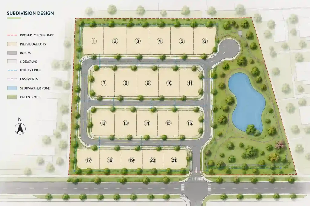
A complete subdivision design site plan contains far more information than property boundaries and proposed lot lines. Every element included on the drawing helps planning officials evaluate whether the development meets safety, engineering, and zoning requirements. While every municipality has its own checklist, several components appear on nearly every subdivision site plan submitted for approval.
Property Boundaries and Existing Site Conditions
Every site plan begins with clearly defined property boundaries verified by a professional land survey. These boundaries establish the legal extent of the project and provide the framework for all proposed improvements. Existing features such as buildings, roads, utility lines, water bodies, easements, fences, and significant vegetation are also shown because they may influence how the subdivision is designed.
Including existing site conditions helps reviewers understand how the proposed development interacts with the surrounding environment. Reviewing a site plan example for permit can also help developers understand how existing and proposed features should be presented on a professional drawing. It also reduces the risk of conflicts with neighboring properties or existing infrastructure during construction.
Proposed Lot Layout
The proposed lot layout is one of the most closely reviewed portions of the site plan because it determines how future homes or commercial buildings will be arranged across the property. Each lot must comply with local zoning standards related to minimum size, frontage, setbacks, and overall dimensions.
A well-designed layout also considers future usability. Lots should provide practical building areas, efficient driveway access, and logical connections to utilities. Good subdivision design balances regulatory compliance with long-term functionality, ensuring that each parcel remains valuable and easy to develop after approval.
Road Design and Transportation Planning
An efficient road network is one of the most important aspects of any successful subdivision. Planning departments carefully review how vehicles, pedestrians, cyclists, and emergency services will access and move throughout the development. Poorly designed roads can create traffic congestion, reduce safety, and increase long-term maintenance costs. A subdivision design site plan should clearly identify:
- Public and private roads
- Cul-de-sacs and intersections
- Sidewalks and crosswalks
- Bicycle paths (where required)
- Emergency vehicle access
- Connections to existing streets
These details help local agencies determine whether the subdivision will function efficiently once occupied. Beyond meeting engineering standards, a well-planned road network improves traffic flow, enhances neighborhood connectivity, and creates a safer environment for future residents.
Utility Infrastructure Planning
A subdivision cannot function without reliable utility services. Before approving a development, municipalities must verify that every proposed lot can connect to essential infrastructure without overloading existing public systems. A typical utility plan includes:
- Water mains
- Sanitary sewer lines
- Stormwater pipes
- Electrical service
- Natural gas lines
- Telecommunications infrastructure
- Fire hydrants and utility easements
Developers should coordinate with utility providers early in the planning process rather than waiting until construction begins. Planning utility connections on a site plan early helps reduce conflicts during design review and construction. Addressing utility capacity and infrastructure upgrades before submission helps avoid costly redesigns and keeps the project moving smoothly after approval.
Stormwater Management and Drainage Design
Stormwater management is one of the most heavily regulated aspects of subdivision development. Every new project changes the natural flow of water, making proper drainage essential for protecting neighboring properties, nearby waterways, and public infrastructure. A well-prepared subdivision design site plan typically shows:
- Retention or detention ponds
- Drainage swales
- Culverts
- Catch basins
- Underground drainage pipes
- Discharge points
Planning departments also review grading plans to ensure water flows safely away from buildings and roadways while minimizing erosion. Addressing drainage requirements early reduces revision requests and helps create a safer, more sustainable community.
Understanding Zoning and Development Regulations
Every municipality has zoning regulations that determine how land can be developed. Understanding how zoning permits affect development projects can help developers avoid design changes later in the approval process. Before preparing a subdivision design site plan, developers should carefully review these requirements to ensure the project complies with local standards. Important zoning requirements often include:
- Minimum lot sizes
- Frontage requirements
- Setback distances
- Maximum building heights
- Density limits
- Parking requirements
- Open space requirements
Ignoring these regulations can result in multiple review cycles and costly redesigns. By incorporating zEven small mistakes can lead to multiple review cycles, additional engineering costs, and unnecessary project delays.oning standards into the initial planning process, developers improve their chances of obtaining faster approvals while creating a subdivision that aligns with the community’s long-term development goals.
Common Mistakes That Delay Subdivision Approval
Many subdivision applications are delayed not because the project is unsuitable, but because important details are missing or fail to meet local requirements. Even small mistakes can lead to multiple review cycles, additional engineering costs, and unnecessary project delays. Reviewing the most common site plan errors before submission can help developers identify issues that frequently delay planning approvals. Some of the most common issues include:
- Incomplete boundary or topographic surveys
- Lot layouts that don’t comply with zoning regulations
- Missing easements or utility information
- Poor stormwater drainage planning
- Inaccurate engineering calculations
- Lack of coordination between project consultants
For example, outdated surveys or missing utility information can make it difficult for planning officials to evaluate the proposal accurately. Likewise, lot layouts that don’t meet minimum size, frontage, or setback requirements often require significant redesign before approval can move forward.
Developers should also pay close attention to stormwater management and consultant coordination. Inadequate drainage plans or inconsistencies between engineers, surveyors, and architects can trigger additional review comments and slow the approval process. Taking the time to review every detail before submission helps reduce revisions and improves the chances of receiving faster approval.
Tips to Improve Your Chances of First-Round Approval
Developers who invest time in proper planning are far more likely to receive approval without multiple revision cycles. A well-prepared subdivision design site plan demonstrates professionalism, minimizes costly mistakes, and gives planning departments the information they need to review the project efficiently. To improve your chances of first-round approval:
- Work with experienced civil engineers and land planners.
- Verify local zoning and subdivision requirements before designing.
- Conduct accurate boundary and topographic surveys.
- Coordinate with utility providers early in the planning process.
Another step that can make a significant difference is scheduling a pre-application meeting with the planning department. These meetings allow developers to discuss the project, clarify local requirements, and identify potential concerns before investing in detailed engineering work. Before submitting your application, make sure it includes all supporting documentation, such as:
- Engineering calculations
- Environmental or drainage reports
- Traffic studies (if required)
- Utility coordination documents
- Any municipality-specific application forms
Submitting a complete and organized application reduces review comments, speeds up the approval process, and increases the likelihood of obtaining approval on the first review.
Why Professional Site Plan Services Make a Difference
Preparing a subdivision involves far more than creating an attractive layout. Every line on the drawing must comply with engineering standards, zoning ordinances, environmental regulations, and utility requirements while supporting the long-term functionality of the community. Professional site plan providers help developers by:
- Preparing accurate, permit-ready drawings
- Identifying potential issues before submission
- Coordinating with engineers and surveyors
- Ensuring compliance with local regulations
- Reducing costly revisions and project delays
Working with experienced professionals often saves both time and money during the approval process. Investing in professional site plans and plot plans gives developers accurate, permit-ready drawings that support a smoother review process. A well-prepared subdivision design site plan improves communication between all project stakeholders and increases the likelihood of receiving faster approvals with fewer revision requests.
Conclusion
A successful subdivision begins long before roads are built or homes are constructed. It starts with a carefully prepared subdivision design site plan that demonstrates how the development will function safely, efficiently, and in compliance with local regulations. From property boundaries and lot layouts to utilities, drainage systems, and transportation networks, every element plays an important role in securing project approval.
Developers who invest in careful planning, accurate engineering, and professional site plan preparation are better positioned to complete the approval process with fewer delays and lower overall costs. By understanding what planning departments expect before submitting an application, you can move your project forward with greater confidence and create a development that is both compliant and built for long-term success.
If you’re planning a new subdivision, working with experienced site plan professionals can help ensure your plans meet local requirements, simplify the review process, and keep your project on schedule.
Frequently Asked Questions
What is a subdivision design site plan?
A subdivision design site plan is a detailed drawing that shows how a property will be divided and developed. It includes lot layouts, roads, utilities, drainage systems, easements, and other features required for planning approval.
Is a subdivision design site plan required before development approval?
Yes. Most municipalities require a subdivision design site plan before reviewing or approving a land development project. It helps planning officials verify compliance with zoning, engineering, and infrastructure requirements.
Who prepares a subdivision design site plan?
Subdivision site plans are typically prepared by licensed civil engineers, land planners, or surveyors who understand local development regulations and municipal submission standards.
How long does subdivision approval usually take?
Approval timelines vary depending on the project’s complexity and the local jurisdiction. Smaller developments may receive approval within a few months, while larger subdivisions often require multiple review cycles before final approval.
Can a subdivision design site plan be revised after submission?
Yes. Planning departments frequently request revisions if additional information or design changes are needed. Addressing review comments promptly helps keep the approval process moving efficiently.